The Pamirs and Tian-Shan are two great mountain systems of Central Asia, two high-mountainous regions in the center of the Eurasian continent. Together, they form a single freshwater reservoir. These two mountain systems play a peculiar role of “water-bearing area”. If it were not for these two mountain systems, then Central Asia would have turned into a desert that now surrounds the Pamirs and Tian-Shan from the north and south.
There is still a tectonic confrontation between these two mountain systems, where the Pamirs press on the Tian-Shan. Thus, various landscapes, mountain ranges and valleys are formed here. This is the most dynamic area on Earth. Here you can observe various natural processes, natural disasters and relief transformation. Travelers who have visited the Pamirs and Tian-Shan have always been impressed by the splendor of the natural heritage of these mountain systems.
The sharply continental climate and the amplitude of heights have formed many forms of magnificent relief here, conditioned the life of people and created various ecosystems. Until now, these two mountain areas are still not fully explored.
Our project is a photo of the exploration of the unknown. We want to explore and capture almost unknown, wild and highly aesthetic natural heritage sites. We plan to find beautiful and amazing places in the most hidden corners of the Pamirs and Tian-Shan
We want to take photographs of rare animals living here, endemic plants and moments of ethnography and traditions of different peoples inhabiting these mountains.
Objective of the project:
– Tell people about these two great mountain systems, about their nature, about the people who live here,
– To preserve the natural heritage of the two countries, Kyrgyzstan and Tajikistan,
– To organize in the future a photo exhibition for the local population, so that the peoples living here see the depth of their unique nature, so that they are proud of the place where they live,
– Create photo album and travel guide.
It is possible that your photos will be the impetus for the organization of new Geoparks or nature reserves. Photos will show governments and ordinary people the beauty of these great mountain systems.
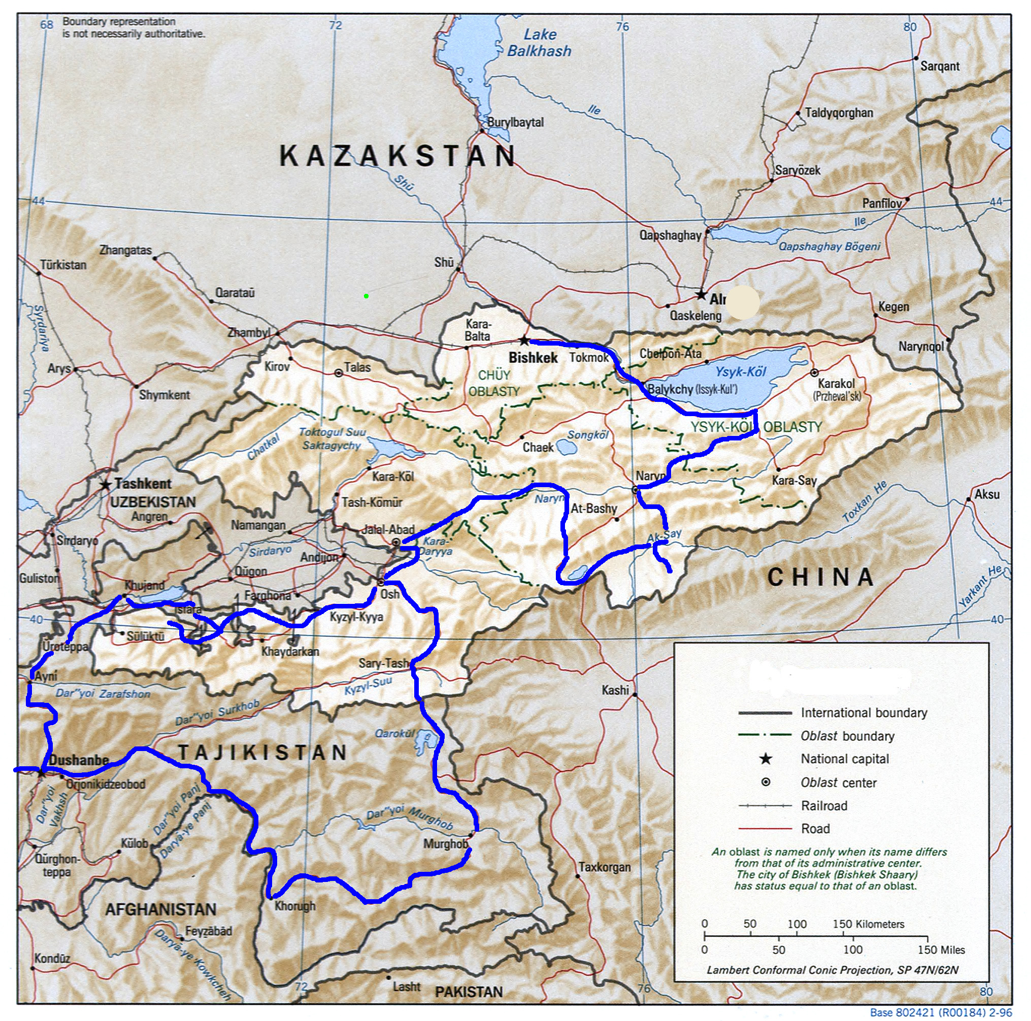
The length of our trip is more than 4500 km
– Duration of the expedition – 16 days
– The maximum number of participants is 20 pax.
– Transport – off-road vehicles with 3 or 20 seats


ROUTE of the EXPEDITION
PROGRAM
Day 1. Arrival in Bishkek
Briefing. Acquaintance with the guide. Hotel accommodation.
Day 2. Bishkek - Issyk-Kul Lake - Barskaun - Arabel
After breakfast, the route lies east to Issyk-Kul Lake. From Bishkek to the lake, the road rises almost 1000 m above sea level. Further, along the southern coast, we will find ourselves in the Barskaun gorge. This is an amazing place with beautiful waterfalls. Further, a pass (3800 m) awaits us, after which we will descend into the Arabel valley. The landscape of the valley resembles a tundra with numerous lakes. Overnight in yurts.
Day 3. Arabel - Burkhan valley - Naryn
The further route passes through the high mountain valleys. The local landscapes are immense. The Burkhan river valley joins with the Small Naryn river valley. Then we will reach the Naryn City located at an altitude of more than 2000 m. Overnight at the hotel.
Day 4. Naryn - Kol-Suu lake - Kok-Kiya canyons
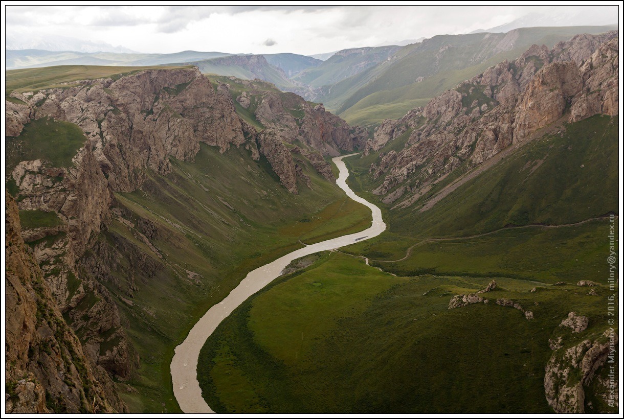
After breakfast, our route lies in the South Tien-Shan. We will go up to the At-Bashi valley. Here are located only the camps of local shepherds, who, in the spring, rise here from the nearest villages. Then we will find ourselves in the wild nature of the Kokshaal-Too mountain range and the valley of Kok-Kiya river . Overnight in yurts.
Day 5. Excursion to the Kol-Suu lake and the Kok-Kiya canyons
The lake was formed as a result of a large landslide. Now, the lake is sandwiched in a narrow canyon. Now, it is a very aesthetic place that attracts sophisticated tourists. Overnight in yurts.
Day 6. Kokshaal-Too - Chatyr-Kul lake - Tash-Rabat
The further path continues to the west along the At-Bashi valley. We will drive around the high-mountain Chatyr-Kul lake and get to Tash-Rabat – an ancient Christian temple. Some scholars argue that the ancient building of Tash-Rabat is located on the Great Silk Road and is a resting place for trade caravans. But other specialists consider it a Christian temple. Overnight in yurts.
Day 7. Tash-Rabat - Baetov - Kazarman - Jalal-Abad
On this day we will see several natural landscapes. They are different from each other. From the high-mountainous zone we will find ourselves in the low-mountain zone of the Fergana Valley.
On the way we will see the magnificent landscapes formed by the badlands. We will cross the Fergana Range and find ourselves in the Fergana Valley – one of the largest and most fertile valleys in Central Asia. We will see various landscapes, geological forms and endemic vegetation. Hotel accommodation.
Day 8. Jalal-Abad - Osh - Sary-Tash
The further route lies to the Pamirs. We will pass the ancient Osh City, which is located on the Great Silk Road. Then, along the Pamir highway, we will reach the high-mountainous Alai valley. The valley is an alpine meadow. The Alai Valley is the geological boundary between the Pamir and the Tien-Shan. Overnight at the guest house.
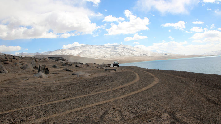
Day 9. Sary-Tash - Kara-Kul
The road to the Pamir begins from Sary-Tash. We will climb to the high-mountainous Markansu desert (over 4000 m). Here, surrounded by mountains, is the highest lake in the world – Kara-Kul. The lake is surrounded by sandy and rocky deserts. The climate here is very harsh. Therefore, the first part of our trip to the Tien Shan was acclimatization to cope with the higher mountains in the more severe Pamirs. In a small village of the same name, Kyrgyz shepherds live, who graze yaks in these places. We will take an excursion to the lake. Overnight at the guest house.
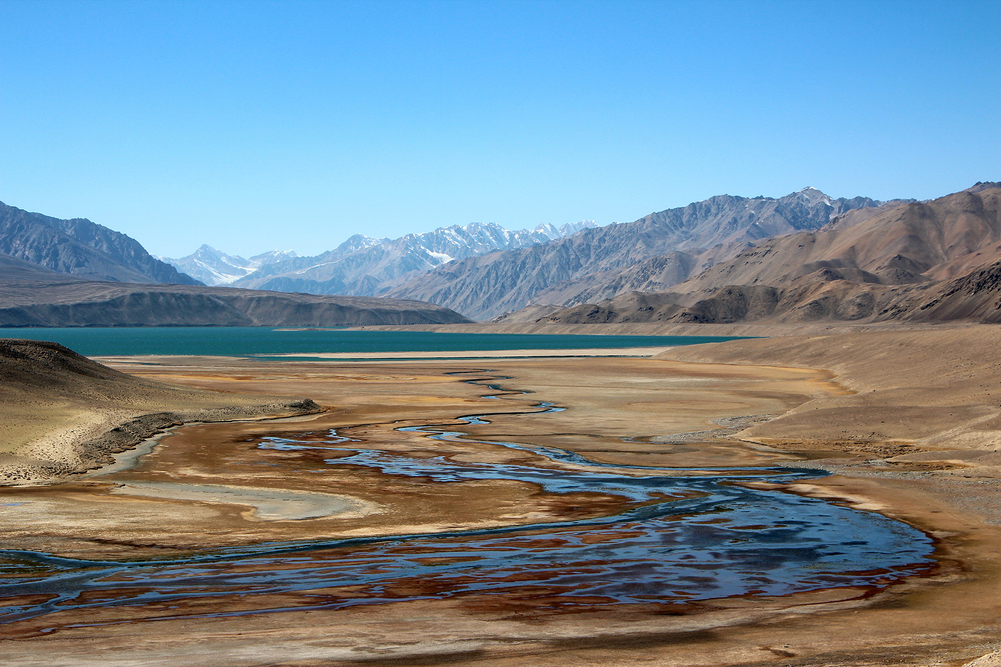
Day 10. Kara-Kul - Murghab - Bulunkul lake
The further route leads us through the territory of the Tajik National Park. We will see outstanding mountain landscapes along the way. We will see different peoples speaking different dialects. We will enjoy the magnificent high-mountain lakes Sysykul Bulunkul and Yashilkul. The entire path lies through the sandy-rocky desert. Overnight in the home of a local family.
Day 11. Bulunkul - Khorog
Excursion to the lakes Bulunkul and Yashilkul. The lakes are located in the natural park. A small village Bulunkul consisting of 20 houses is located in a desert area where there is no electricity and communication. But, on the other hand, there is a magnificent Pamir nature. Many panoramic photos can be taken here. And also here you can take unique photographs from the life of local residents and photographs of wildlife. The way to the Khorog city lies through mountain valleys and passes. Accommodation at the hotel in Khorog.
Day 12. Khorog - Rushan - Dushanbe (525 km)
Further, our journey continues along the roads of the Pamirs. On the way, we will cross the large Pamir Rivers Bartang, Vanj and other mountain rivers. The road runs along the Pyanj River. The river is the border between Tajikistan and Afghanistan. We will see deep canyons and alpine deserts. Hotel accommodation.
Day 13. Dushanbe - Shirkent Natural Park
Dushanbe is the capital of Tajikistan. It is a very beautiful and modern city. As in the rest of Tajikistan, the people of Dushanbe are very hospitable. On this day we will take an excursion to the Shirkent Historical and Natural Park. In the park there is a rock wall with dinosaur footprints. This place is one of the largest in the world with traces of dinosaurs. Return to the capital. Overnight at the hotel.
Day 14. Dushanbe - Khujand
For 310 kilometers you will see a real contrasting Tajikistan. We will cross the Zeravshan and Turkestan mountain ranges, through the highest passes in Central Asia. We will reach the hottest area on the banks of the Sardarya River – the Khujand Сity. It is an ancient city with a rich history. There are many museums and attractions here. Hotel accommodation.
Day 15. Khujand - Batken - Madygen
On this day we will leave Tajikistan and move to Kyrgyzstan. After 200 km we will find ourselves in one of the most magnificent natural monuments. This place is a Geopark. Photographers will find many geological landscapes and panoramas here. These places represent natural heritage and claim the status of world natural importance. Overnight in tents in the Madygen tract.
Day 16. Madygen - Batken - Osh
The entire route passes through the valleys of the southwestern part of Kyrgyzstan. Hot semi-deserts give way to cool oases. Arrival to the ancient Osh city. Hotel accommodation.
Day 17. Osh - Airport
Transfer to Airport. Those who wish can continue their journey and enjoy the old city – a shopping center on the Great Silk Road.
Those interested can finish the expedition in the Dushanbe city and fly to home
Price on request
According to the request and interest, we can negotiate the optimal price for your budget.
Price depends on the number of participants
The optimal number of participants is 1 – 15 persones
Our email: info@geoexplorersclub.com