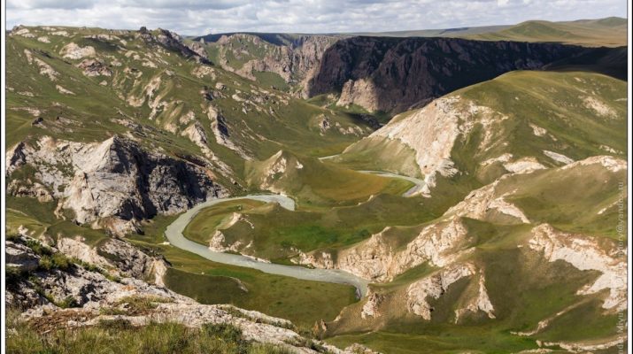
About the Kok-Kiya Canyon
Vertical walls reach about 300-400 m. At different levels of the inaccessible walls you can see black holes, which can continue as caves. Thickets of shrubs and tall grass grow in the canyon. At the bottom of the canyon you can find surprisingly wild and untouched nature. The river turns into a serpentine, forming large meanders. Down the channel, the river periodically presses against the rocky walls and then forms low grassy terraces. These terraces serve as a great place for a temporary camp.
You can also descend into the canyon from above, along some valleys flowing into it from the left. Being on the brink of the left ledge of the canyon, you can observe magnificent panoramas of the canyon.
We do not know if there are rapids at the bottom of the canyon forming waterfalls along the way down. If there are, then you have to go up out of the canyon and down into the canyon again to bypass these vertical sections of the path at the bottom of the canyon.
At the beginning of the path, the canyon is formed in granite rocks, and then it continues in limestone rocks. Here you can observe geological contacts and how rocks are transformed as a result of metamorphism under the influence of heat in the depths of the earth in past geological epochs. The canyon has its own microclimate, flora and fauna. Here you can watch the wildlife and practice photography.
About the Kokshaal Range
Kakshaal-Too is a mountain range in the system of the Central Tien-Shan, on the border of Kyrgyzstan and China. The name of the range comes from the Kyrgyz language “Kakshaal” – “Terrible Mountains” or “Non-accessible Mountains”.
Remoteness, wildness and uncertainty are the concepts that characterize and give an idea about this area of Tien-Shan. Before the collapse of the USSR, these areas were closed. Only border guards and, with rare exceptions, shepherds were rarely allowed to be here. Almost the entire territory of the district is occupied by inaccessible range: Kokshaal-Too Barkaldoy, Karly-Too. The prevailing altitude of the ranges is 3400-5600 meters. The highest point is the Dankov peak (5982 meters) which is located in the eastern part of the Kokshaal-Too range. The ridges of ranges are predominantly narrow, rocky, with deep saddles and sharp tops in the form of pyramids and peaks. Along the foot of the cliffs there is powerful debris of stones and rubble. Above 4000-4400 meters, the mountains are covered with eternal snow and glaciers.
The length of the range is about 400 km. The range is composed of shale, sandstone, limestone and granite intrusions and is mainly an alpine relief. On the northern slope there are steppes, on the southern slope there are meadow steppes and alpine meadows.
For the first time the area was discovered by a Russian expedition. In connection with the growing interest of Russia in Central Asia since 1856, the first research expedition began coming here. One of them was led by the Russian geographer A.V. Kaulbars, who led an expedition to study the mountainous area south of the Naryn River in 1869.
About the At-Bashi Range
At-Bashi is a mountain range between the At-Bashi valley in the north and the Ak-Sai valley in the south. Translated from Kyrgyz it means the head of a horse. The length of the ridge is 135 km; the maximum altitude is 4786 m.
The range is composed of Paleozoic metamorphic schist, limestone, sandstone, partly eruptive rocks (granite, syenite). There are glacial landforms on the watershed. Modern glaciation covers an area of about 150 square km. These are mainly mountain meadow and subnival landscapes. The southern slopes of the ridge are very different from the northern ones. The northern ones represent alpine meadows as the southern stony semi-desert slopes. The reason for these differences is the orientation of the ridge from east to west.
About the Tash-Rabat
The Tash-Rabat was built in the 15th century on the site of a more ancient Christian monastery from the 9th to 10th centuries. There are two versions of its occurrence. Historians and archaeologists argue who, when, and why built this stone building.
Some people think that the Tash-Rabat is a medieval transshipment base of trade caravans on the Great Silk Road. Others think that this building is a testimony of the monastery of Nestorian Christians. Both versions have the right to exist, because in the Middle Ages, traders and wandering monks walked on the same paths.
Perhaps when the Islamic religion finally settled in Central Asia, the monastery began to decline. Then it began to serve as a caravanserai on the Great Silk Road. This circumstance did not allow the temple to turn into ruins.
It is believed that the Tash-Rabat was a key point in the passage of caravans through the Tien-Shan, as not only provided shelter for merchants, but also served as a fortification during the robbers raids. Trade caravans were sent from China to the cities of the Fergana Valley through the Tash-Rabat.