Dates can be changed for individual groups.
This trip does not require special high knowledge in various geological areas. The program can be adapted for schoolchildren and students, or for young scientists, as well as lovers of wildlife, geology, paleontology, mineralogy, and geography. This expedition attracts everyone, from beginners to experts. The field program is flexible and can be changed for a specific audience of field researchers. In this trip, we will tell you in accessible language about the geological structure of the great Central Asian mountain systems of the Tian-Shan and Pamir, as well as the geological processes taking place in the earth’s crust and beyond.

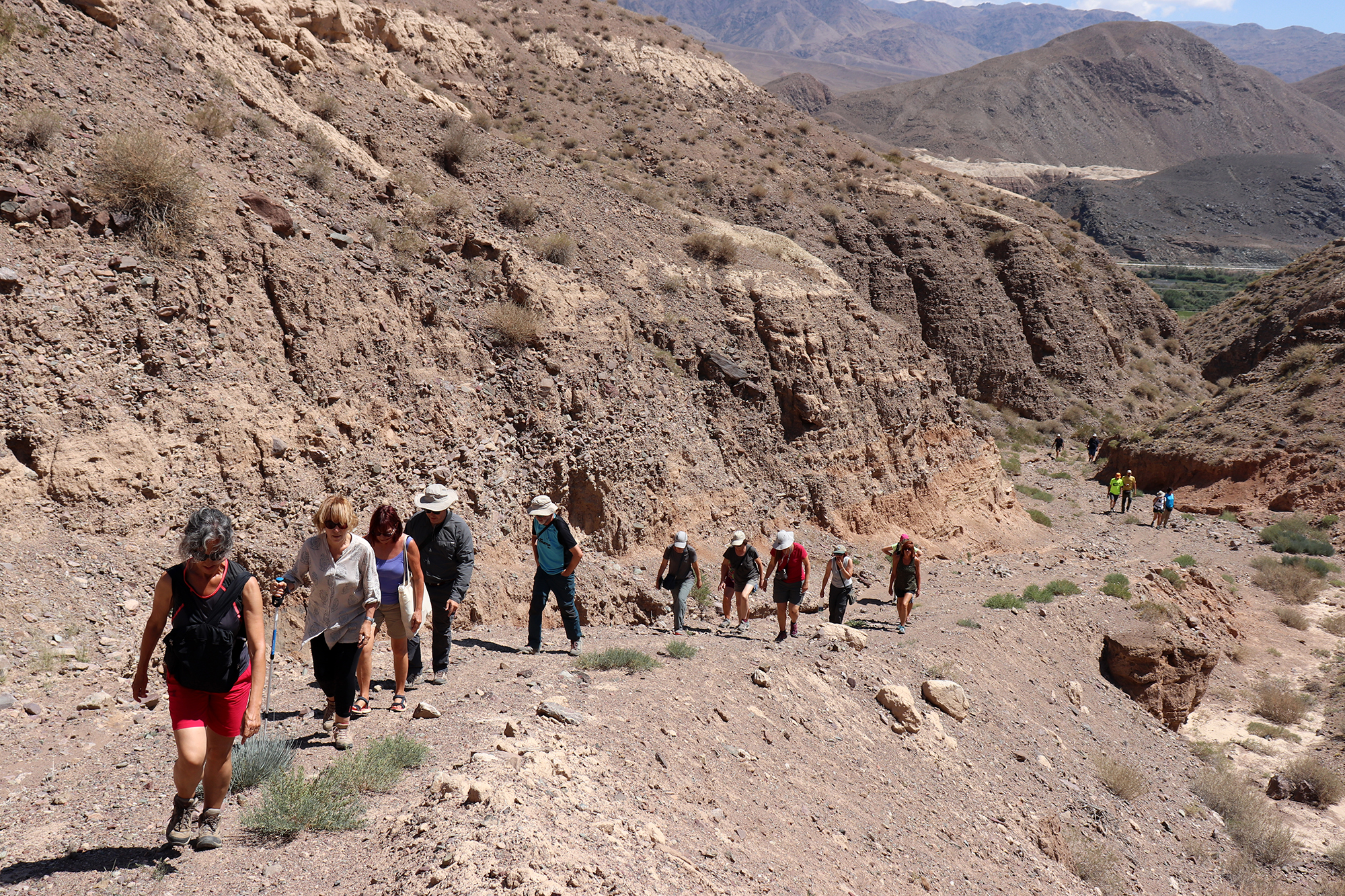
On this trip we will visit national parks, geological heritage sites, mines, quarries, caves, canyons and lakes. Our route passes through different landscapes, from glacial to semi-desert. We will visit the territories of potential Global Geoparks. This is an opportunity to see the entire geological history, from Precambrian to Holocene ages. Daily experts will make briefings about relief, geology, geological processes, in accessible language. During the trip you can see stunning landscapes, local cultural sights, accompanied by incredible wildlife and fascinating stories of people. During this field expedition, you will be able to participate in excursions to local historical sites, swim and have a boat trip in the Issyk-Kul Lake, go down to a real mine, and try national dishes.
Our experts have significant professional experience acquired through many years of field expeditions and are well aware of the geology of the Tian-Shan, Pamir-Alay, not only in Kyrgyz territory, but also in Central Asia. The duration of the program is 20 days. The duration can be changed at the request of the participants. The total length of the route is about 3850 km. The most favorable time for the trip is May – September.
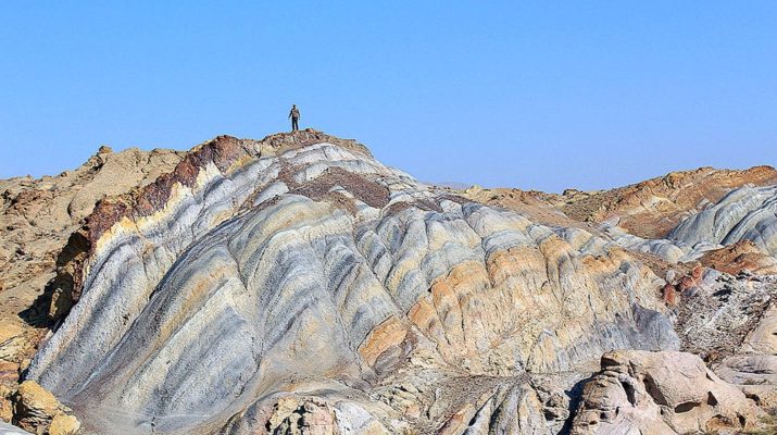
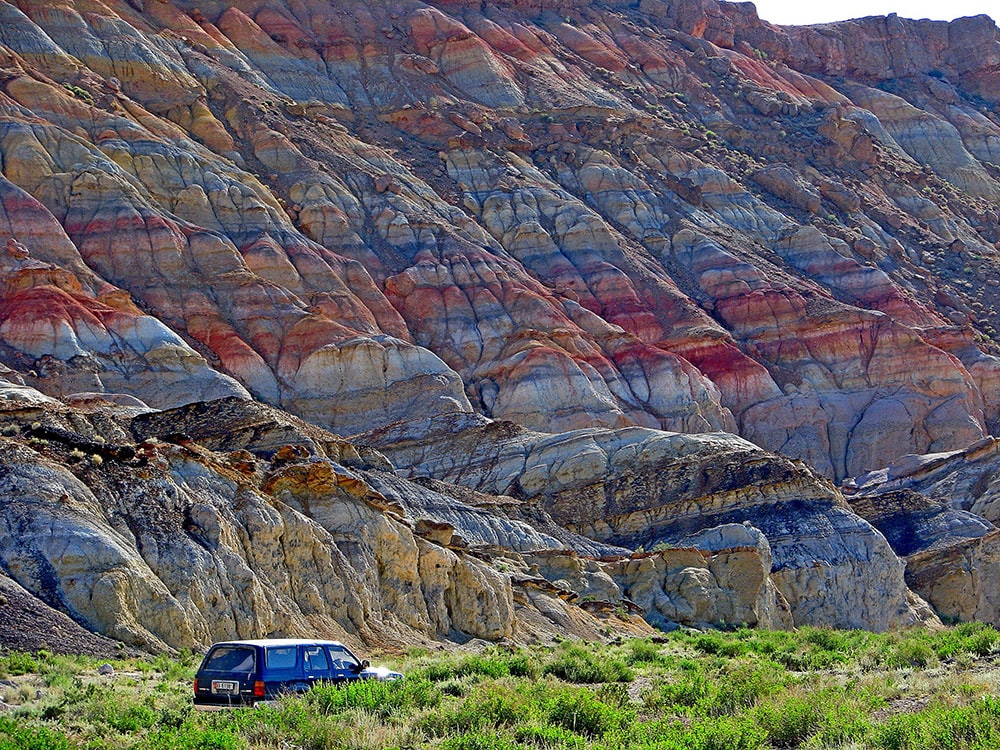
Photos of the geological heritage of the Tian-Shan
Photos from the geological tour “Geology of Tian Shan”, 2019
Topics for our geological excursions:
- Tectonic evolution and structure of the Earth’s crust in the Tian-Shan, Pamir and adjacent regions of the Central Asian folded belt
- Geodynamics and seismicity of Tian-Shan
- Geomorphology and Quaternary geology of Tian-Shan
- Mineral deposits of Tian-Shan and Pamir-Alay (Kyrgyzstan)
- Geological threats
- Natural resources and ecosystems

Introduction. Tian-Shan is an area that you can explore indefinitely and still not fully understand it. Therefore, the geology of Tian-Shan cannot be understood in a single trip. In this program we will try to explore and understand the main issues of the origin of the great mountain system. We will consider the basics of its geological structure, see natural processes occurring in dynamically developing mountain conditions, and also get to know people living in Tian-Shan. Tian-Shan is a combination of intermountain depressions and mountain ranges parallel to each other. This combination led to the diversity of landscapes and climatic conditions.
During the field trip, we will try to solve several practical geological issues:
- Structural and geological analysis; Geological mapping of deployed geological complexes; – Geological hazards in Tian-Shan and Pamir-Alai.
- We will describe exogenous geological processes; we will define the area of possible damage in the event of a landslide.
Before starting a field trip, there are two important questions that have to be answered:
– What is the Tian-Shan and its geographical affiliation, as well as what is Kyrgyzstan?
The Tian-Shan is the heart of the most active Central Asian folded belt. The Central Asian folded belt is a huge mountain system that stretches from Kazakhstan to the Far East. It is the core of the Eurasian continent and occupies the central and most active part of Eurasia. The Central Asian folded belt was the beginning of the formation of the Eurasian continent.
The Indian-Australian Plate moves towards Eurasia at a speed of 7-8 cm per year. The Pacific plate, plunges under the eastern outskirts of Asia at a speed of 8-11 cm per year, reducing the size of the ocean itself and bringing to the Asian outskirts not only the North American, but also the South American continental blocks. Perhaps, in 200 million years, the Eurasian continent will be the site of the future supercontinent of “Amazia”, which includes almost all the continents of the Earth.
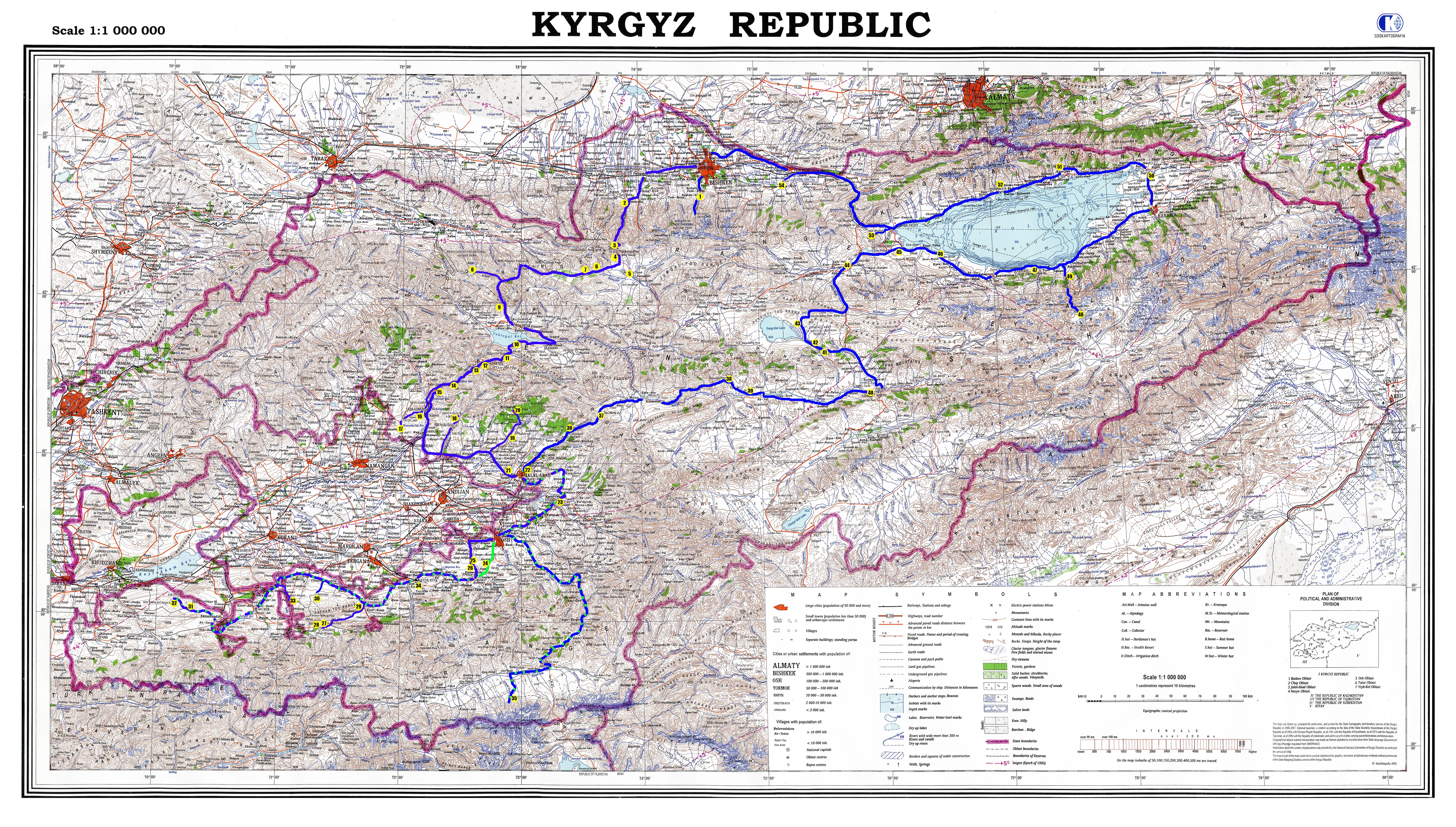
Program. In this program, we show only about 50 stops. But on this trip we will make about 100 stops.
 PROGRAM
Meeting at the airport. Overnight at hotel.
Presentation of the program, a geological essay on the Tien-Shan and the Central Asian folded belt. After the presentation, we plan to visit the mineralogical museum. Further our route will continue to the mountains. We will head to the Ala-Archa and Chon-Kurchak gorges to better understand the tectonic contact between the Chui valley and the Kyrgyz ridge, Location 1. The Kyrgyz ridge is the northern border of the Tien-Shan. From here begins the Tien-Shan mountain system. In the foothill zone, we have a panoramic view of the Chui Valley and the city of Bishkek. Here we will see a vivid example of the tectonic zone of the junction of the mountain range and the largest valley in Tien-Shan, which testifies to the movement of lithospheric plates forming the entire folded region of Tien-Shan. Overnight at hotel.
Along the way, we will explore the active faults in the western part of the Chui Valley, Location 2. After we overcome a series of mountain serpentines, we will get into a tunnel that was built in one of the highest passes in Tien-Shan – the Tuya-Ashu. Next we will make a Location 3 in order to understand the geological conditions in which this tunnel was built. After the tunnel, the inner regions of Tien-Shan begin. One of the high valleys of Suusamyr (2600 m) is a very harsh cold place in winter and beautiful alpine meadows in summer. From the pass, there is a magnificent view of the classic high-alpine landscape of Tien-Shan. Here you can understand the general tectonic structure of the Suusamyr valley, which is a sunken block jammed between mountain ranges, Location 4. In the Suusamyr valley we have two tasks: to understand the general tectonic and geological structure of the intra-mountain depressions by the example of the Susamymyr valley, and also to see evidence of modern tectonic activity, Location 5. A modified riverbed pattern caused by modern active tectonics in the valley of the Chon-Korumda River, Location 6. Change of the riverbed pattern as a result of neo-tectonics of Tokoylu, Location 7. Overnight at the picturesque resort with kymyz therapy.
Today's route crosses the tectonic structures of the Northern Tien-Shan and leads us to the regional tectonic border between the Northern and Middle Tien-Shan. After the Ala-Bel pass (3000 m), the descent begins along one of the most attractive river valleys of Tien-Shan – the Chychkan gorge. During the descent, landscapes change, from alpine to semi-desert. In the forest zone, our route will lead us to the Itagar Lake, Location 8. The lake was formed as a result of the collapse that occurred in the late Cenozoic age and blocked the gorge. The Itagar gorge is a favorite place of local nomads and collectors of wild berries of raspberry and blackberry. Next stop is an abandoned marble quarry, Location 9.
Further, the route leads us to the Ketmen-Tube valley (670 m above sea level). Here we learn about the Toktogul reservoir, ancient historical events related to the Ketmen-Tube valley, as well as hydropower resources of Kyrgyzstan, Location 10. In 1962, the active construction of the Toktogul hydroelectric station began on one of the major Tien-Shan Rivers, the Naryn River. The depth of the gorge reaches 1500 m, and the steepness of the slopes is 65–70 °. The dam was built in extremely difficult seismic conditions 9-10 points. Overnight at the hotel on the shore of the reservoir.
Our route continues to the Southern Tien-Shan. We will cross the Talas-Fergana fault – a major tectonic disruption of the earth's crust, crossing the entire Tien-Shan. Its length is over 800 km. The rift starts in China and ends in Kazakhstan.
Along the way we will get acquainted with various geological structures, stratification elements and tectonic contacts. We will see the metamorphic and volcanic rock complexes. We will use this opportunity for practical training in structural geology, Location 11. We will study examples of local metamorphism in the limestone quarry, Location 12.
On the way to Tash-Kumyr, we will study the volcanic complex and geological structures along the Kara-Kul – Tash-Kumyr road, Location 13. Locations 14, 15 and will be excursions to the metamorphic rock complexes. Here one can observe folded structures, corrugations, flexures, and layers of rocks and also, tectonic, stratigraphic inconsistencies. Examples of tectonic inconsistencies formed between mountain deposits of the Paleogene (P) and Quaternary (Q) periods, anticline, syncline, monocline and other forms of folds.
Further is the city of Tash-Kumyr. It is the vanguard of the coal industry of Kyrgyzstan. In the vicinity we will visit deposits of quartzite, coal and limestone. A factory was built for the production of polycrystalline silicon (poly silicon) here. This material is intermediate between amorphous silicon and mono-crystalline silicon,Location 16. To the west of Tash-Kumyr there is the Kyzyl-Jar semi-desert that resembles a savannah. This place is subject to study by paleontologists. In 1966-67 parts of the Sauropod skeleton were found here. Here we will see magnificent panoramas of the semi-desert landscape created by the Meso-Cenozoic red rocks, Location 17. Today's excursion will end in the secret city of Mailuu-Suu. Overnight at hotel.
The Mailuu Suu town was a secret city during the Soviet times. Today it is a forgotten city. Mining intervention caused the emergence of large landslides and outflow of the city’s population. Here we will make a dinosaur plateau excursion, Location 18. We have to find out what kind of dinosaurs this tracks imprinted on limestone surface belong to? Officially, these tracks are not registered. During our tour, we can put forward a theory about the origin of these tracks. The first petroleum in the Fergana Valley was discovered and extracted in the vicinity of Mailuu-Suu.
On the way to Arslanbob, we will see a natural landslide museum, Location 19. Some of the landslides blocked the river and created hazardous situation. In Arslanbob we will visit the small and large waterfalls. Their altitude is 30 m and 110 m. This place is sacred for numerous pilgrims from the whole Fergana Valley. Arslanbob is a relic walnut forest of world importance. This is the only walnut forest of such a large scale in the world. Arslanbob is a mountain village and resort at the same time, which makes it a great tourist attraction in Kyrgyzstan. Overnight in a national Uzbek guest house.
Today we will visit the famous waterfall and the world's largest walnut forests, Location 20. The vast areas of fruit and walnut forests in the valley of the Arslanbob River occupy an area of more than 600,000 hectares. Each year, around 1,500 tons of walnuts are harvested in Arslanbob, as well as 5,000 tons of apples, pistachios and cherry plums. For many years, Arslanbob, which means “King of Forests” in Kyrgyz, has been a national reserve. Walnuts from this area were transported to different parts of the world during the heyday of the Great Silk Road. The life span of walnut trees can exceed thousands of years. Their branches form an extensive crown, and the altitude of such trees reaches 30 meters. Walnut trees usually grow on mountain slopes and along river banks at altitudes from 1000 to 1800 meters above sea level — Arslanbob itself is located at an altitude of 1700 m above sea level. Besides the rich nutrients of walnuts, hazelnut wood is pretty valuable too because it is used for making good furniture.
Today's route leads us to the Kugart River, Location 21. In 1994, during heavy precipitation, water from the river flooded the nearest settlements. There was a threat of flooding in the large city of Jalal-Abad. The cause of the catastrophe was a breakthrough of the side dike protecting the right bank of the river. The bed of the Kugart River originates in the high belt of the Fergana Range. When released into the eastern lowland part of the Fergana Valley, the river becomes a source of intensive accumulation of detrital material. For many years, this accumulation has become problematic for the surrounding areas, as the river bed has become higher than the surrounding relief.
Next, Location 22 in the country's oldest resort, in the Jalal-Abad City. The resort is located on the hills of pistachio and almond trees. The resort appeared on the site of thermomineral springs. Hydro-mineral springs in Kyrgyzstan are common in Tien-Shan and in the Pamir-Alai. The genesis of hydrothermal processes has a direct connection with the tectonic activity of the mountain system.
Next, Location 23 in the Uzgen City – the ancient capital of the Karakhanid dynasty (IX-X centuries), and a large city in southern Kyrgyzstan. We will visit the minaret and mausoleum of the rulers of the Karakhanids. Next we get to the Osh City. Overnight at hotel
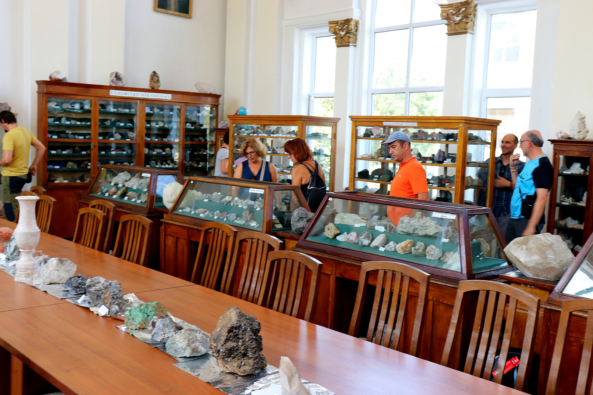
In the ancient Osh City (3000 years), we will visit the geological museum. The museum contains minerals and rocks of the entire southern region of Kyrgyzstan. With a local geologist, we will have a lecture on the geology of the Southern Tien-Shan and the Pamir. We will also make an excursion-climbing Mount Suleiman-Too – a cultural heritage of the UNESCO. The history of the city is connected with the global history of Central Asia. Osh was a trade hub on the Great Silk Road. On the Suleiman-Too Mountain there are ancient petroglyphs, as well as a local history museum, which anyone can visit. In the afternoon, free day. Overnight at hotel.
In the morning we leave Osh and go to the karst regions of the Alay and Turkestan foothills. Our further path goes along the 40th parallel. We will drive through the famous Karst district of “Osh Hills”. In these relatively small limestone massifs, speleologists have discovered about 60 caves. Genetically, the Osh hills are paleo-karst outcrops. During geological history, these limestone remnants experienced two births that would be above the ground. Of course, this is due to tectonic processes in the collision of the Pamir and the Tien-Shan. On the way, we will visit a gypsum-selenite deposit, which is mined here using open methods, Location 24. The presence of gypsum here suggests that these geological formations of rocks were formed in the Mesozoic, which lie above the Paleozoic formations. From here there is a magnificent panorama of the Alai Range and the intermountain valley.
Next we will visit the easily accessible caves in the karst massif of Tuya-Muyun. Our main task is the Fersman Cave, named after the Russian academic Alexander Fersman, a pioneer in the study of mineral resources of the USSR in the beginning of the 20th century, Location 25. The origin of all the caves in Tuya-Muyun is the hydrothermal karst. One of them is the Barite cave, Location 26. This cave is famous for its rare barite crystals in the form of clusters. From Tuya-Muyun to the west stretches the Mercury-antimony hydrothermal belt. Deposits of antimony, mercury, and other paragenetic minerals are formed along the belt. In the 20s of the 20th century, along the hydrothermal mineral belt, deposits of lead and silver were discovered and developed. At the same time, the first radium deposits were discovered, which were later used to produce Stalin's first atomic bomb. Further, our route will lead us to the mining village of Haidarkan, founded during the Soviet Union. It is still mined for antimony – antimonite in the form of metallic-colored crystals (Sb2S3). We will visit one of the existing mines to see the process of mining, Location 27. Then we will visit the old quarry, Location 28. Our next Location is 29; we will make an excursion to the Tegermech thrust. The Tegermech thrust, is a good example of the geological structure of the world's largest antimony deposits, and is also a unique example of the tectonic structure of the Southern Tien-Shan. A thrust is a Silurian (S) strongly metamorphosed sediment that lies over Devonian (D) limestone. Here, we will have a discussion about the tectonic mechanism of the formation of the thrust. Overnight at hotel in Kadamjay.
In the morning, a short seminar on the topics: antimony and mercury deposits in the south of Tien-Shan (Kadamdzhai, Chavai and Haidarkan); hydrothermal zone of mercury and antimony of Southern Fergana; Geodynamics of the Tegermech thrust. After the seminar, we will go to the southwest of the country along the Southern Fergana hydrothermal belt, where we will make interesting observations and descriptions of some outstanding landscapes and geology of the region. On the way is Location 30, for an excursion to an abandoned lead quarry in the ghost town of “Sovetskoye”. The city originated during the USSR in the midst of mining programs. After the collapse of the country, terrain and mining declined due to lack of funding and economic problems. But local people support life in the city, doing trade and agriculture. Currently, the pit is flooded by a lake, which allowed it to be used as a recreation area. The route from Kadamjay lies on semi-desert terrain.
Finally we will reach Madygen – an oasis among dry semi-desert terrain. This is the westernmost point of our route. Here we see some of the history of the Great Silk Road. Here are some medieval metallurgical centers, in which precious metals were produced at that time. These metal products were exchanged for other goods. The metal ore was mined by slaves who worked here in medieval mines. We will visit one of the places where medieval smelting furnaces have been preserved, which were used to extract lead and silver mined in the Kan-i-Gut cave mine, Location 31. Next, our route passes through the Sary-Too Mountains – a unique geological heritage. They are composed of geological layers of the Jurassic and Cretaceous age. The mountains are painted with rocks of different colors; this creates magnificent panoramas and landscapes. Here we will conduct paleontological observations and geological descriptions. Along the way, in addition to photographing impressive panoramas, we will visit the remains of the metallurgical complex of the IX and X centuries. At the end of the day we will arrive in Madygen, a pleasant oasis of old poplars that exist here thanks to karst springs. Overnight in field camp.
Today our tours take place in the vicinity of Madygen. We will have a walk through an impressive limestone canyon. In the canyon, we will study the results of erosion, tectonics and sedimentology. Next we will head to Sary-Too, translated from the Kyrgyz as “orange mountains”. Here we will study the geological sections and paleo-fauna.
We will visit a place where local people use primitive methods in a primitive mine in the Jurassic (J) layers to mine coal, Location 32. In the evening there will be a seminar on the Mesozoic-Cenozoic geological complex of rocks in Sary-Too, as well as examples of geological mapping and neotectonics of the area. Madygen and Sary-Too is an excellent testing ground for studying geological structures and their genesis; it is an open-air geological museum. Overnight in field camp
Today is a road day, as we return to Osh. Along the way, we will make an excursion into the "depths of the Earth". This will allow us to see the structure of the Cretaceous (K) geological section from the inside. We will do this through a cave, and thus we will see from which geological layers consists the Cretaceous period. We can interpret what we see inside with the geological structure outside, in the vicinity of the Ak-Turpak Cave. That is, we will study the geological structure of the Cretaceous geological section, from the inside in the cave, Location 33. The cave is formed in the thinner plaster rocks, at the contact of the Cretaceous-Paleogene age layers. Inside the cave we will see layers of gypsum-selenite. On the opposite (left) bank of the Sokh River, we will see the periclinal of a fold composed of exactly the same red-colored layers of the Cretaceous-Paleogene age (K-P). A further route continues to the city of Kyzyl-Kiya, another avant-garde of the coal industry in Kyrgyzstan. Here we will make an excursion to the Institute of Mining and Nature Management, Location 34. Here, we will visit the training mine, where we will hold a seminar, which will cover the topics: coal deposits of Kyrgyzstan; the unique hydrogeological characteristics of the Abshir-Ata, Zhydalik and Azimbulak waterfalls; structural and petrographic characteristics of Mesozoic volcanic formations. In the evening we will arrive in Osh. Overnight at hotel.
In the morning we will go on a trip to the Pamir, to its northern border – Zaalai Range (it is also called Chon-Alai Range). The route passes along the famous Pamir highway, which was built by the military during the USSR, in order to defend the southern borders of the country. Along the way we will see alpine meadows, overcome high passes through the Alai Range, see impressive landslides in the mountain town of Gulcha and we will pass along the inner mountain valleys composed of Paleozoic and Mesozoic rocks. Then we will get into the high mountain Alai valley (2500 m), which is the result of interaction between the great mountain systems Tien-Shan and the Pamir. Then we will stop at the base camp of alpinists under the Lenin Peak (7134 m), where we will visit the zone of glaciers and moraines, as well as make an excursion to Tulpar-Kul Lake.
Our trip continues in the Hercynian region of Tien-Shan. Therefore, we will try to understand the interaction between the Pamir and Tien-Shan. Understand the basic tectonic mechanism of formation of modern geological structures.
Thus, along the Pamir Highway we will move to a fundamentally different geological and geographical world of Central Asia. This place is called Achik-Tash, which translates as “Open Stone”. Overnight at field camp.
Early in the morning we will make an excursion to one of the Tulpar-Kul moraine lakes, Location 35. Our path passes through a landscape of green hills composed of fragments of ancient moraine deposits covered with steppe vegetation, among which you can see edelweiss everywhere. Along the way, we will continue our geological observations and delve into a discussion of previous topics on tectonics, geology, history, and others. Being at the northern border of the Pamir, you will feel like an insignificantly small creature on Earth. Pamir is a great mountain structure, which differs from Tien-Shan. From the Tulpar-Kul lake opens a panorama of the Alai range, the southernmost range of the Tien-Shan mountain system. Next, we return to our camp for lunch. Then we will start to leave the Pamir, and the route will continue to Jalal-Abad – the city occupying the easternmost tip of the Fergana Valley. Along the way, we will see contacts of the Mesozoic red layers with Paleozoic gray limestone. Overnight at hotel in Jalal-Abad.
Leaving the Fergana Valley, we leave the Southern Tien-Shan. Our further route runs along the Kugart River to the watershed of the Fergana Range. Thus, we are moving from the Hercynids of the Southern Tien-Shan to the Hercynian-Caledonian districts of the Middle Tien-Shan. The Talas-Fergana regional deep tectonic rift passes along the Fergana Range. On the southwestern slopes of the ridge, we will see thickets of relict walnut forest. On the way, we will study landslides that have arisen in loess rocks, Location 36. Reaching the pass (3000 m) is Location 37. After the pass we descend to the valley of the Naryn River near the village of Kazarman – a small village that has arisen on the site of a gold deposit. This region is quite different from previous landscapes. Here we will see a different climate and completely different impressive landscapes. On the way to the city of Naryn, we will get into a dry valley, where we can observe the results of the suffusion process.
Next, we reach the Kara-Koo Pass, from where one can see a breathtaking panorama of the badlands and mountain ranges, Location 38. Next is Location 39, where we can observe the results of suffusion in a dry valley. The further path lies in the badlands in the middle of Naryn. Our route passes through the paleo-bottom of the Mesozoic sea, where we can observe the formations formed in the vanished sea. Now there are various erosion and accumulative forms of landscape. In the evening we will arrive to Naryn – a high mountain town in the inner Tien-Shan. During our seminar we will consider three questions: 1. Caledonian and Hercynian orogenesis of the Middle Tien-Shan; 2. Tectonic evolution of Tien-Shan; 3. Natural risks in the area of the city of Naryn, a system for monitoring hazardous geological processes. Overnight at the hotel in Naryn.
Today we will make a morning excursion in the vicinity of Naryn. This city is a classic example of high mountain cities, which is exposed to various natural hazards. Today we will see one of the most common processes in this region – debris flows. The city is threatened by more than 70 mudflow valleys. We will see the problem of shortage of land. The big canal, which flows above the city, creates the risk of hazardous situation, Location 40.
Then we drive north to the highland zone of the Middle Tien-Shan to get to the highland Son-Kul Lake (3016 m). Our route lies among the majestic mountains and alpine meadows. We will see mountain ranges with deep canyons. In some places, the limestone mountains of the Carboniferous period (C) are in contact with the granite pluton of the Permian period (P), the contact between which is well traced in some places. We will drive along the "The most important structural line of Tien-Shan – the line of Nikolaev." This line represents an important regional tectonic zone separating the Middle Tien-Shan from the Northern Tien-Shan. Along the tectonic line of Nikolai, there is a zone with various signs of active tectonics. Along the way, we will be able to see several signs in the Karatal-Dzhapryk canyon, Location 41. This place is a nature reserve. Karst and caves with calcite crystals are developed here.
We will take a walk through the canyon. This is a great opportunity to explore the various geological structures that will cause a debate about their nature.
Further, our route will continue to the pass called “33 parrots”. On the way, we will make an excursion to the “Granite Waterfall”, stop 42. Finally, we will reach Son-Kul Lake – a large alpine lake of Tien-Shan, Location 43. It is located between mountain ranges at an altitude of 3016 m above sea level. Around the lake are virgin pastures and a conservation area. The lake is fed by groundwater and small rivers flowing from the surrounding glaciers. The lake is inhabited by 10 species of fish, such as the: Coregonus lavaretus Coregonus nasus Coregonus peled, Schizothorax intermedius, Diptychus dybowskii, Diptychus gymnogaster, Diptychus maculatus, Diptychus sewerzowi, Noemacheilus dorsalis, Noemacheilus stoliczkai. The Son-Kul Lake is a unique reservoir on the path of many species of migratory birds and represents an important ecosystem for their migration between the regions of Asia, Africa and Europe. Next, we leave Son-Kul and descend into the Kochkor Valley. Upon arrival in Kochkor, we will visit a small workshop of famous Kyrgyz products made of felt, Location 44. Overnight at guest house in Kochkor.
Today our main goal is to reach Issyk-Kul Lake, one of the largest lakes in Central Asia and the second largest mountain lake in the world. Along the way we pass the Orto-Tokoi reservoir with its amazing river delta. We have to cross the colorful desert Ak-Olong, where among the Paleozoic massifs, small mountain remnants are exposed, consisting of magmatic and metamorphic rocks of the Permian age, where we will have the opportunity to study the syenite crystals, Location 45.
Later we arrive into the Issyk-Kul intermountain depression. Our route will pass along the southern shore of the lake for almost 200 km. The southern coast is characterized by a variety of geological forms and landscapes. Geologically, the eastern part of the southern coast is composed of Lower Cenozoic Paleogene-Neogene formations that form badlands and amazing canyons. Next is Location 46, approximately in the middle part of the southern coast in the region with a panorama of the lake and the surrounding mountain ranges. From here a there is a beautiful view of the lake and the ridges. The lake shore is composed of conglomerates and breccias, reminiscent of the modern tectonic history of the lake. Here we will give a brief insight into the history of the formation of the lake and its current importance to global ecosystems.
During the upper Cenozoic, the lake level fluctuated nine times; the largest fluctuation was at 100 m. Now, modern tectonic movements in the Issyk-Kul region are monitored using GPS stations. As a result, it has been established that currently the process of convergence of the northern and southern coasts is taking place for tectonic reasons at a speed of 4 mm per year. We can see evidence of active tectonics, during the following Location 47, in the valley "Skazka". The valley is an object of active tourist visits.
In the evening, our seminar will be devoted to the geological history of the Issyk-Kul Lake formations and the geological structure of the area. Overnight at yurt camp on the lake in the Bokonbaevo village.
Today we will go to the Barskoon valley to visit the Arabel highland valley. Our route will be about 80 km. For a relatively long climb, we will rise from an altitude of 1,650 m to 4,000 m. Therefore, our climb must be slow in order to acclimatize. The Arabel Valley is a rare expression of an ancient Peneplain. The valley was raised to an altitude in the Oligocene without tectonic deformation of its Paleozoic basement. Next, is Location 48 in the Arabel Valley. The climatic conditions of the valley are quite severe. But these are the best habitats for the Marco Polo mountain sheep, sometimes followed by the snow leopard. The Arabel Valley is an expression of the high-mountainous steppe landscape with a background of the nival climate zone. Hundreds of glacial lakes and ancient moraines are formed here.
The Barskoon Valley is beautiful! During the USSR, cosmonauts who made space flights underwent rehabilitation here. After his first flight into space, the first cosmonaut Yuri Gagarin came here in 1965, Location 49. In honor to the cosmonauts, a memorial monument was erected here. After the excursion to Arabel, we will return to the Issyk-Kul depression and go to the city of Karakol. Karakol is one of the most touristic cities of Kyrgyzstan. Karakol is the gateway to the Central Tien-Shan.
After the journey of the Great Russian traveler Pyotr Semenov-Tian-Shansky (1856-1857), the first Europeans from Russia began to move to this new region of Russia. In the IXX century the first Russian immigrants who began to develop agriculture appeared here. In the city of Karakol operates an ancient wooden church, included in the UNESCO heritage list. We will make a tour of the sights of the city.
Then our route continues around the lake. Next, is Location 50, at the mouth of the Tup River. Here we can see evidence of periodic fluctuations in the lake. This place is also a favorite for many species of migratory birds and a place of observation for ornithologists. The Tup River is the largest of the 80 tributaries of the lake. But none of the rivers flows out of the lake, so the lake is a drainless. During the last 500 years, changes in the water level in the lake led to the flooding of ancient settlements. Today it is established on the archaeological remains of the ancient Scythian city of Chigu - 2 c AC The Scythians or Saks lived around Issyk-Kul before the appearance of the Kyrgyz here in the 10th century, evidence of which are the mounds, which are located along the entire coast
Further, our path goes to the village of Ananievo, where there was a large landslide of seismic origin, Location 51. It was the result of the strongest earthquake of 1909 with the epicenter in Hindu Kush in northern Afghanistan, with a magnitude of 7.7 Richter points and an intensity of 9 on the Mercaldi scale. Next, we will arrive in the resort town of Cholpon-Ata. Here we will visit a stone park with lots petroglyphs, Location 52. This is a popular open-air museum, which is called the Stone Garden. It covers an area of 42 hectares. Prehistoric monumental images and petroglyphs of 2000 BC – 4 c AC are depicted on the stones. This object is under the protection of the UNESCO. Overnight at hotel.
Today we return to the capital, where we began our fascinating tour. On the way, we will make an excursion to the beautiful Cenozoic canyons of Kok-Moinok, where we will study the signs and evidence of the migration of the Issyk-Kul Lake to the east, Location 53. Next, along the way we will visit the historical and archaeological complex of Burana, Location 54. Overnight at hotel.
Departure home
- - Meeting and seeing off at the airport
- Accommodation in hotels 3 * according to the program (double occupancy)
- Tents for accommodation
- Large tent for the kitchen and dining room
- Three meals a day for the whole program,
- Transport according to the program,
- Guide-expert,
- Cook,
- Entrance fees to reserves and museums
- Rent equipment
- International airfare to Bishkek and back
- Equipment rental
- Surcharge for single occupancy
- Cost of visa and consular services
- Personal expenses in a hotel: bar, international calls, etc.
- Insurance
- Any changes to the program
Price on request
According to the request and interest, we can negotiate the optimal price for your budget.
Price depends on the number of participants
The optimal group is from 3 to 25 persones
Accommodation in hotels:
- – Bishkek – 3 nights
- – Suusamyr – 1 night
- – Toktogul – 1 night
- – Mailu-Su – 1 night
- – Arslanbob – 1 night
- – Osh – 3 nights
- – Kadamjay – 1 night
- – Jalal-Abad – 1 night
- – Naryn – 1 night
- – Kochkor – 1 night
- – Bokonbaevo – 1 night
- – Cholpon-Ata – 1 night
Total: 15 nights
Accommodation in the field camp:
- – Madygen – 2 nights
- – Achik-Tash (Pamir) – 1 night
Total: 3 nights
Our email: info@geoexplorersclub.com